5.3.2.1.2. Approaches for determining baselines
Most projects to date have adopted a two-step approach to determine baselines.
First, the likely fate of terrestrial ecosystems within the project boundary
is predicted. Second, changes in carbon stocks that would occur as a result
of this scenario are estimated.
Specification of the without-project scenario for the project area usually
have been based on projections of past trends of land use into the future. These
predictions have taken into consideration events that are expected to alter
current behavior (changes in legislation related to land use and tenure, changes
in market preferences or prices, changes in environmental awareness, etc.).
Even a thoroughly investigated without-project baseline, however, is prone to
the risk that unexpected social or policy changes will confound predictions
over the longer time frame. For example, the baseline for a reduced-impact logging
project could change radically if national policy dictated adoption of this
practice in all forest concessions. Key factors used in projecting the baselines
have included planned land-use decisions of landowners/stakeholders, designation
of land by national authorities, and historical patterns of land-use change
in the local area.
Different approaches likely would be required, however, for different types
of projects operating in different circumstances:
- Afforestation projects might use simple models that predict zero uptake/emissions
without intervention.
- Projects to conserve forests used by small farmers are likely to need models
that reflect local demands for agricultural land, firewood, and timber.
- Projects aiming to reduce emissions through better forest management may
need models that compare technological alternatives.
Different approaches for data collection have been used, including compilations
of national/regional statistics, satellite imagery, and interviews with relevant
authorities and key stakeholders. There is debate about the level of detail
required and the weight given to different criteria (historical trends, available
technology, population pressure, etc.) (Busch et al., 1999).
Several approaches have been proposed and/or used during the AIJ Pilot Phase
for deciding how to carry out baseline projections. These approaches vary with
regard to data requirements and treatment:
- Simple, logical arguments do not use quantitative methods for predicting
changes in current trends (or use simple ones). For example: "Without intervention,
the forest concerned will be sold for agricultural development" [Rio Bravo
project (Programme for Belize, 1997a)] or "without intervention, loss of aboveground
carbon stocks within the area will continue at approximately 1.5 percent per
year" [Scolel Té pilot project (Tipper et al., 1998); see also Box
5-2]. Variations of this approach have been used by most projects during
the AIJ Pilot Phase [e.g., the NKCAP in Bolivia (Brown et al., 2000);
the RIL project in Sabah, Malaysia (Pinard and Putz, 1997); the PAP in Costa
Rica (SGS, 1998)].
- Spatial or social-economic models simulate land-use change processes
on the basis of factors such as proximity of towns, roads, and agricultural
frontiers; population growth; food requirements; and the productivity of local
agricultural technology [e.g., LUCS model (Faeth et al., 1994); Ludeke,
1990; Jepma, 1995). This approach is being used in The Nature Conservancy's
project in Guaraqueçaba, Brazil (Brown et al., 1999a,b).
- Econometric models use an econometric treatment to data factors such
as historical series of productivity, price, costs, and so forth. This approach
has not been used in the AIJ Pilot Phase, but it has been discussed in a few
publications (e.g., Chomitz, 1998).
Simple, logical arguments are not necessarily less accurate in terms of predictive
ability. Their applicability will probably be limited, however, to specific
areas and contexts. Increasing model complexity is likely to be required to
attempt credible predictions across a range of land uses. Such models, however,
generally require large amounts of input data and may still be poor predictors
of specific local changes. Requirements for complex baseline models could represent
a serious barrier to small-scale projects or initiatives in poorer countries
unless "umbrella" approaches are adopted (Bass et al., 2000). Procedures
for selection or approval of models and a program for model testing and improvement
to ensure some degree of consistency and quality would have to be considered.
|
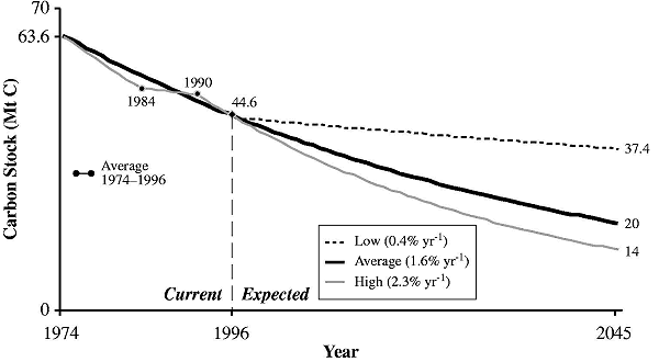
Box 5-2. Historical and Projected Carbon Storage in
an Area of ~300,000 ha in the Highlands of Chiapas, Mexico, based on
a Series of Multi-Spectral Scanner (MSS) Images
|
|
|
A series of satellite images, from 1974 to 1996, was
used to estimate changes in land use between 12 categories of vegetation/land
use for an area of approximately 300,000 ha in the highlands of Chiapas.
Measurements of the biomass of each vegetation type were then used to
derive an estimate of the change in carbon stocks. Extrapolation of
the historical changes of carbon stocks into the future can be used
as a basis for without-project baselines. Because the rate of land-use
change varied considerably over the 1974 to 1996 period, however, so
did the baseline rate of carbon loss over the time period chosen as
the reference. The spatial frame of reference used to derive estimates
of land-use change is also important. Deforestation activity is often
concentrated in particular areas (e.g., along roads and river valleys).
The historical rate of change may therefore vary considerably according
to the geographical coordinates of the reference area.
|
Once a baseline scenario for land-use and ecosystem changes has been developed,
changes in carbon stocks associated with this scenario must be estimated. Different
approaches have been used or proposed during the AIJ Pilot Phase (see examples
in Table 5-4), including the following:
- Quantification of carbon in proxy areas [e.g., the NKCAP (Brown et al.,
2000)]
- Control plots where project activities are not applied, which are set aside
for measurement of carbon stocks in the absence of the project intervention
[e.g., the RIL project in Sabah, Malaysia (Pinard and Putz, 1997)]
- Modeling [e.g., the PAP in Costa Rica (SGS, 1998)]
- Combinations of the foregoing approaches.
|