|
2.4.2. Measurement of Stocks
Two types of methods are used to measure losses or accumulations of carbon
on land: methods that measure stocks of carbon and methods that measure fluxes.
Measurement of stocks at the beginning of 2008 and at the end of 2012 (or at
the date of commencement of the activity between 2008 and 2012) will yield the
change in stocks that has occurred over the commitment period. Alternatively,
measuring the flux of carbon into or out of an ecosystem over the 5-year period
will also yield the net change.
2.4.2.1. Vegetation Inventory
The emphasis in this section is on forests. Nevertheless, there are appropriate
and accurate techniques for measuring stocks of carbon in the vegetation of
grasslands and other non-woody ecosystems.
2.4.2.1.1. Inventory techniques for stemwood volume
Techniques and methods for measuring terrestrial carbon pools that are based
on commonly accepted principles of forest inventory, soil sampling, and ecological
surveys are well established (Pinard and Putz, 1996; Kohl and Paivinen, 1997;
MacDicken, 1997; Post et al., 1999). All of these methods are suitable for project-
and national-level surveys. Methods for measuring the fluxes of non-carbon GHGs
are less well developed; at least for biomass burning, however, their magnitudes
are often based on changes in carbon pools and corresponding emission ratios
(Crutzen and Andreae, 1990).
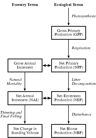
Forest inventories are traditionally carried out to inform forest managers
about the state of their forests in terms of area, species, age classes, growing
stock (quantity of wood), and net annual increment (see Figure
2-8). These inventories traditionally have been carried out by ground measurements
only; now, however, they usually include a combination of remotely sensed and
ground data.
|
|
Figure 2-8: Equivalent terms as used in forestry
and ecology. Note that forestry terms usually apply to the stemwood
volume of forest ecosystems alone and ecological terms to the whole
ecosystem.
|
A continuous forest inventory typically consists of collecting pre-information,
interpreting aerial photographs, designing the sample network, carrying out
the field work, and processing data. The sample network consists of transects
or grids of sample plots in the area to be inventoried (thus, they can be set
up specifically for ARD projects). Along these transects, plots are selected
in which at least the diameter of all trees and the height of some trees are
measured. These data are processed and aggregated to the desired scale. Based
on allometric relations and growth models, the total volumes and net annual
increment can be assessed. When required, whole-tree biomass can be assessed
using additional allometric relationships (or expansion factors). Thus, inventories
can also detect changes in forest biomass that are caused by the adoption of
an activity that falls under Article 3.4 of the Protocol-for example, changes
in harvest intensity. A shortcoming of inventories, however, is that they do
not cover very young stands accurately because measurements usually start when
trees (seedlings) have reached a certain diameter at breast height. Below that
limit, the stand is recorded as a clear-cut. This may be a problem in inventorying
lands under Article 3.3.
The advantage of inventories is that they can be carried out for practically
all scales of a project-from a single stand to a project covering millions of
hectares. The sampling intensity of most national-scale inventories is such
that individual plots represent large land areas. For example, 10 European countries
have forest inventories in which a single field plot (~25 trees) represents
around 200 to 1000 ha (Kohl and Paivinen, 1997).
There is an optimal size for plots in any given vegetation; this optimal size
represents a compromise between statistical efficiency and sampling practicality.
A common goal is to define the required precision of sampling, which then determines
the number of plots required for a given plot size. The absolute uncertainty
(e.g., 95-percent confidence) for biomass pools should be of similar magnitude
to the absolute uncertainties of other components in the inventory. Inventories
can be carried out so that they yield very accurate results; at the country
level, for example, producing uncertainties (95-percent confidence) for forest
land area of ±0.4 percent, growing stock ±0.7 percent, and total increment ±1.1
percent (Tomppo, 1996). Providing a relation between the number of plots on
the one hand and costs and precision on the other is not simple, however, because
that relation varies enormously between forests, countries, etc.
Continuous forest inventories have been carried out for all Annex I countries.
There are considerable differences in precision and definitions between these
countries, however. Therefore, variables reported by one country cannot always
be compared to the same variables for another country (European Commission,
1997). The TBFRA 2000 project (UN-ECE/FAO, 2000) seeks to encourage data gathering
based on a harmonized set of definitions.
Most developing countries possess only a forest area estimate assessed sometime
between 1970 and 1990, although considerable progress has been made with remote-sensing
techniques. Some time series on permanent plots of forest growth and biomass
do exist, but most of the other data derive from scattered temporary plot measurements
assessed under various research projects (Phillips et al., 1998).
Although national forest inventories would most likely detect lands under Article
3.3, the inventory sampling schemes will have to be adapted to cover forest
dynamics with adequate precision and over the correct time period (2008-2012).
Typical national inventories are carried out in a 10-year cycle and are often
staggered, with different regions completed in different years. It may be possible
to use models to adjust the estimates to the required reporting periods by using
annual planting and felling data or to inventory more frequently. Sampling schemes
may have to be adapted, however, where the area of lands under Article 3.3 constitutes
only a small percentage of the total forest area. Detection of these lands may
require increased frequency of remote-sensing data, and higher intensity of
field data collection may be necessary to assess carbon stock changes accurately.
Most of the methodologies for assessing changes in forest area, whether based
on terrestrial sampling or remote sensing, have limitations in detecting small
changes in carbon and ARD activities on small patches of land. Terrestrial sampling
allows for accurate measurement of a country's total forest area (error <1 percent);
if only areas where ARD has occurred are to be considered, however, the error
will be higher, especially if ARD areas are small in comparison to the total
forest area. ARD activities on areas smaller than 1 ha might be difficult to
assess, even with high-resolution satellites. The difficulty is not with the
resolution of the satellite data but with determining the nature of the observed
change: Is it related to ARD activities or is it the result of other factors,
such as natural tree falls or the mortality of an individual tree?
|