B.2 Observed Changes in Precipitation and Atmospheric Moisture
Since the time of the SAR, annual land precipitation has continued to increase
in the middle and high latitudes of the Northern Hemisphere (very likely to be
0.5 to 1%/decade), except over Eastern Asia. Over the sub-tropics (10°N
to 30°N), land-surface rainfall has decreased on average (likely to be about
0.3%/decade), although this has shown signs of recovery in recent years. Tropical
land-surface precipitation measurements indicate that precipitation likely has
increased by about 0.2 to 0.3%/ decade over the 20th century, but increases are
not evident over the past few decades and the amount of tropical land (versus
ocean) area for the latitudes 10°N to 10°S is relatively small. Nonetheless,
direct measurements of precipitation and model reanalyses of inferred precipitation
indicate that rainfall has also increased over large parts of the tropical oceans.
Where and when available, changes in annual streamflow often relate well to changes
in total precipitation. The increases in precipitation over Northern Hemisphere
mid- and high latitude land areas have a strong correlation to long-term increases
in total cloud amount. In contrast to the Northern Hemisphere, no comparable systematic
changes in precipitation have been detected in broad latitudinal averages over
the Southern Hemisphere.
It is likely that total atmospheric water vapour has increased several per
cent per decade over many regions of the Northern Hemisphere. Changes in
water vapour over approximately the past 25 years have been analysed for selected
regions using in situ surface observations, as well as lower-tropospheric measurements
from satellites and weather balloons. A pattern of overall surface and lower-tropospheric
water vapour increases over the past few decades is emerging from the most reliable
data sets, although there are likely to be time-dependent biases in these data
and regional variations in the trends. Water vapour in the lower stratosphere
is also likely to have increased by about 10% per decade since the beginning
of the observational record (1980).
Changes in total cloud amounts over Northern Hemisphere mid- and high latitude
continental regions indicate a likely increase in cloud cover of about 2% since
the beginning of the 20th century, which has now been shown to be positively
correlated with decreases in the diurnal temperature range. Similar changes
have been shown over Australia, the only Southern Hemisphere continent where
such an analysis has been completed. Changes in total cloud amount are uncertain
both over sub-tropical and tropical land areas, as well as over the oceans.
B.3 Observed Changes in Snow Cover and Land- and Sea-Ice Extent
Decreasing snow cover and land-ice extent continue to be positively correlated
with increasing land-surface temperatures. Satellite data show that there
are very likely to have been decreases of about 10% in the extent of snow cover
since the late 1960s. There is a highly significant correlation between increases
in Northern Hemisphere land temperatures and the decreases. There is now ample
evidence to support a major retreat of alpine and continental glaciers in response
to 20th century warming. In a few maritime regions, increases in precipitation
due to regional atmospheric circulation changes have overshadowed increases in
temperature in the past two decades, and glaciers have re-advanced. Over the past
100 to 150 years, ground-based observations show that there is very likely to
have been a reduction of about two weeks in the annual duration of lake and river
ice in the mid- to high latitudes of the Northern Hemisphere.
Northern Hemisphere sea-ice amounts are decreasing, but no significant trends
in Antarctic sea-ice extent are apparent. A retreat of sea-ice extent in
the Arctic spring and summer of 10 to 15% since the 1950s is consistent with
an increase in spring temperatures and, to a lesser extent, summer temperatures
in the high latitudes. There is little indication of reduced Arctic sea-ice
extent during winter when temperatures have increased in the surrounding region.
By contrast, there is no readily apparent relationship between decadal changes
of Antarctic temperatures and sea-ice extent since 1973. After an initial decrease
in the mid-1970s, Antarctic sea-ice extent has remained stable, or even slightly
increased.
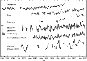
Figure 6: Time-series of relative sea level for the past 300 years
from Northern Europe: Amsterdam, Netherlands; Brest, France; Sheerness,
UK; Stockholm, Sweden (detrended over the period 1774 to 1873 to remove
to first order the contribution of post-glacial rebound); Swinoujscie, Poland
(formerly Swinemunde, Germany); and Liverpool, UK. Data for the latter are
of “Adjusted Mean High Water” rather than Mean Sea Level and include
a nodal (18.6 year) term. The scale bar indicates ±100 mm. [Based
on Figure 11.7] |
New data indicate that there likely has been an approximately 40% decline
in Arctic sea-ice thickness in late summer to early autumn between the period
of 1958 to 1976 and the mid-1990s, and a substantially smaller decline in winter.
The relatively short record length and incomplete sampling limit the interpretation
of these data. Interannual variability and inter-decadal variability could be
influencing these changes.
B.4 Observed Changes in Sea Level
Changes during the instrumental record
Based on tide gauge data, the rate of global mean sea level rise during the
20th century is in the range 1.0 to 2.0 mm/yr, with a central value of 1.5 mm/yr
(the central value should not be interpreted as a best estimate). (See Box
2 for the factors that influence sea level.) As Figure
6 indicates, the longest instrumental records (two or three centuries at most)
of local sea level come from tide gauges. Based on the very few long tide-gauge
records, the average rate of sea level rise has been larger during the 20th century
than during the 19th century. No significant acceleration in the rate of sea level
rise during the 20th century has been detected. This is not inconsistent with
model results due to the possibility of compensating factors and the limited data.
Changes during the pre-instrumental record
Since the last glacial maximum about 20,000 years ago, the sea level in locations
far from present and former ice sheets has risen by over 120 m as a result of
loss of mass from these ice sheets. Vertical land movements, both upward and
downward, are still occurring in response to these large transfers of mass from
ice sheets to oceans. The most rapid rise in global sea level was between 15,000
and 6,000 years ago, with an average rate of about 10 mm/yr. Based on geological
data, eustatic sea level (i.e., corresponding to a change in ocean volume) may
have risen at an average rate of 0.5 mm/yr over the past 6,000 years and at an
average rate of 0.1 to 0.2 mm/yr over the last 3,000 years. This rate is about
one tenth of that occurring during the 20th century. Over the past 3,000 to 5,000
years, oscillations in global sea level on time-scales of 100 to 1,000 years are
unlikely to have exceeded 0.3 to 0.5 m.
|
Box 2: What causes sea level to change?
The level of the sea at the shoreline is determined by many factors in
the global environment that operate on a great range of time-scales, from
hours (tidal) to millions of years (ocean basin changes due to tectonics
and sedimentation). On the time-scale of decades to centuries, some of
the largest influences on the average levels of the sea are linked to
climate and climate change processes.
Firstly, as ocean water warms, it expands. On the basis of observations
of ocean temperatures and model results, thermal expansion is believed
to be one of the major contributors to historical sea level changes. Further,
thermal expansion is expected to contribute the largest component to sea
level rise over the next hundred years. Deep ocean temperatures change
only slowly; therefore, thermal expansion would continue for many centuries
even if the atmospheric concentrations of greenhouse gases were to stabilise.
The amount of warming and the depth of water affected vary with location.
In addition, warmer water expands more than colder water for a given change
in temperature. The geographical distribution of sea level change results
from the geographical variation of thermal expansion, changes in salinity,
winds, and ocean circulation. The range of regional variation is substantial
compared with the global average sea level rise.
Sea level also changes when the mass of water in the ocean increases or
decreases. This occurs when ocean water is exchanged with the water stored
on land. The major land store is the water frozen in glaciers or ice sheets.
Indeed, the main reason for the lower sea level during the last glacial
period was the amount of water stored in the large extension of the ice
sheets on the continents of the Northern Hemisphere. After thermal expansion,
the melting of mountain glaciers and ice caps is expected to make the
largest contribution to the rise of sea level over the next hundred years.
These glaciers and ice caps make up only a few per cent of the world’s
land-ice area, but they are more sensitive to climate change than the
larger ice sheets in Greenland and Antarctica, because the ice sheets
are in colder climates with low precipitation and low melting rates. Consequently,
the large ice sheets are expected to make only a small net contribution
to sea level change in the coming decades.
Sea level is also influenced by processes that are not explicitly related
to climate change. Terrestrial water storage (and hence, sea level) can
be altered by extraction of ground water, building of reservoirs, changes
in surface runoff, and seepage into deep aquifers from reservoirs and
irrigation. These factors may be offsetting a significant fraction of
the expected acceleration in sea level rise from thermal expansion and
glacial melting. In addition, coastal subsidence in river delta regions
can also influence local sea level. Vertical land movements caused by
natural geological processes, such as slow movements in the Earth’s
mantle and tectonic displacements of the crust, can have effects on local
sea level that are comparable to climate-related impacts. Lastly, on seasonal,
interannual, and decadal time-scales, sea level responds to changes in
atmospheric and ocean dynamics, with the most striking example occurring
during El Niño events.
|
|