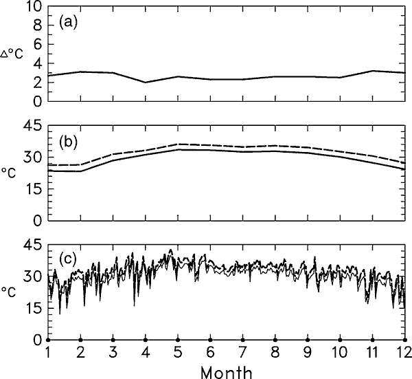
Figure 13.1: Example of
the stages in the formation of a simple climate scenario for temperature using
Poza Rica (20.3° N, 97.3° W) as a typical site used in the Mexican part
of the Rosenzweig and Parry (1994) study.
(a) Mean monthly differences (D) (2xCO2 minus control) of average
temperature (°C) as calculated from the control and 2xCO2
runs of the Geophysical Fluid Dynamics Laboratory (GFDL) GCM (Manabe and Wetherald,
1987) for the model grid box that includes the geographic location of Poza Rica.
The climate model spatial resolution is 4.4° latitude by 7.5° longitude.
(b) The average 17-year (1973 to 1989) observed mean monthly maximum temperature
for Poza Rica (solid line) and the 2xCO2 mean monthly maximum
temperature produced by adding the differences portrayed in (a) to this baseline
(dashed line). The crop models, however, require daily climate data for input.
(c) A sample of one years (1975) observed daily maximum temperature data
(solid line) and the 2xCO2 daily values created by adding the
monthly differences in a) to the daily data (dashed line). Thus, the dashed line
is the actual daily maximum temperature time-series describing future climate
that was used as one of the weather inputs to the crop models for this study and
for this location (see Liverman et al., 1994 for further details).