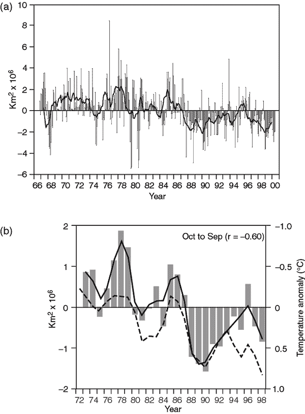
Figure 2.13: (a) Anomalies
of monthly snow cover over the Northern Hemisphere lands (including Greenland)
between November 1966 and May 2000. Also shown are twelve-month running anomalies
of hemispheric snow extent, plotted on the seventh month of a given interval.
Anomalies are calculated from NOAA/NESDIS snow maps. Mean hemispheric snow extent
is 25.2 million km2 for the full period of record. the curve of running
means is extrapolated by using period of record monthly means for 12 months in
the late 1960s in order to create a continuous curve of running means. Missing
months fell between May and October, and no winter months are missing. June 1999
to May 2000 values are based on preliminary analyses. (b) Seasonal snowcover anomalies
(in million km2) versus temperature anomalies (in °C). Both snow
and temperature anomalies are area averages over the region for which climatological
values of seasonal snow-cover frequency (based on the 1973 to 1998 period) are
between 10 and 90%. Season is indicated at the top of each panel. Axis for snow
anomaly on the left-hand-side y axis, axis for temperature anomaly is on the right-hand-side
y axis. Bar plot indicates time-series of snow cover anomalies. Continuous colour
curve indicates nine-point weighted average of snow-cover anomaly. Dashed black
curve indicates time-series of nine-point weighted average of area average temperature
anomaly. Snow-cover calculations are based on the NOAA/NESDIS snow cover data
for the period 1973 to 1998 (updated from Robinson et al., 1993). Temperature
calculations are based on the Jones data set, hence anomalies are with respect
to the time period 1961 to 1990. Snow anomalies are with respect to the time period
1973 to 1998. Correlation coefficient (r) between seasonal snow cover anomalies
and temperature anomalies is indicated in parentheses. (Figure contributed by
David A. Robinson and Anjuli Bamzai, Rutgers University.)