| Working Group II: Impacts, Adaptation and Vulnerability |
| Working Group II: Impacts, Adaptation and Vulnerability |
|
|
|
| Other reports in this collection | |
16.1.3.1. The ArcticInstrumental observations of climatic parameters over
the 20th century are available from standard climate stations on land and measurements
taken on drifting ice floes in the Arctic Ocean. The land stations show that
warming in the Arctic, as indicated by daily maximum and minimum temperatures,
has been as great as in any other part of the world. Although not geographically
uniform, the magnitude of the warming is about 5°C per century, with areas
of cooling in eastern Canada, the north Atlantic, and Greenland (Koerner and
Lundgaard, 1996; Borzenkova, 1999a,b; Jones et al., 1999; Serreze et al., 2000).
Data from ice floe measurements show a slight warming on an annual basis, with
statistically significant warming in May and June over the 1961-1990 period.
Air temperature anomalies in the Arctic basin have been strongly positive since
1993. In the period 1987-1997, air temperature in the Arctic increased
by 0.9°C (Alexandrov and Maistrova, 1998). Significant warming from the beginning of the 20th century has been confirmed by many different proxy measurements (Maslanik et al., 1996; Bjorgo et al., 1997; Smith, 1998). Magnuson et al. (2000) found consistent evidence of later freeze-up (5.8 days per 100 years) and earlier breakup (6.5 days per 100 years) of ice on lakes and rivers around the northern hemisphere from 1846 to 1995 and an increase since 1950 in interannual variability of both dates. Glaciers and ice caps in the Arctic also have shown retreat in low-lying areas since about 1920. Numerous small, low-altitude glaciers and perennial snow patches have disappeared. However, no increasing melting trend has been observed during the past 40 years (Jania and Hagen, 1996; Koerner and Lundegaard, 1996; Dowdeswell et al., 1997). Glaciers in Alaska have receded, with typical ice-thickness decreases of 10 m over the past 40 years, but some glaciers have thickened in their upper regions (BESIS, 1997). Greenland's ice sheet has thinned dramatically around its southern and eastern margins. Above 2,000-m elevation, the ice sheet is in balance, on average. The net effect is a loss of about 51 km3 yr-1. (Krabill et al., 1999, 2000). Snow-cover extent in the northern hemisphere has been reduced since 1972 by about 10%, largely as a result of spring and summer deficits since the mid-1980s (Brown, 2000; Serreze et al., 2000). Most Arctic regions have experienced increases in precipitation since at least the 1950s (Groisman et al., 1991; Groisman and Easterling, 1994; Georgiyevskii, 1998). Measurements from Spitsbergen show a statistically significant increase in precipitation during all seasons, except winter (Hanssen-Bauer and Forland, 1998). Groisman et al. (1994) analyzed seasonal snow extent in the northern hemisphere
and demonstrated an inverse relationship with near-surface air temperature.
Recent findings have provided evidence of a significant decrease in spring snow
extent since 1915 over Eurasia (Brown, 1997) and southern Canada (Brown and
Goodison, 1996). Such trends may be related to low-frequency fluctuations in
hemispheric atmospheric circulation patterns (Serreze et al., 2000). Arctic sea-ice extent decreased by approximately 3% per decade between 1978
and 1996 (Cavalieri et al., 1997; Parkinson et al., 1999; Johannessen
et al., 1999; Serreze et al., 2000). The most significant contractions
were detected in 1990, 1993, and 1995 (Maslanik et al., 1996). Ice composition
also has changed, with a reduction in the area of multi-year ice in winter.
Summer sea-ice extent has shrunk by 20% (880,000 km2) over the past
30 years in the Atlantic part of the Arctic Ocean (Johannessen et al.,
1999), but the shrinkage has only been 5% in the Canadian Arctic Sea. Sea-ice
extent in the Bering Sea experienced a dramatic reduction when a regime shift
occurred in 1976 and has continued to decrease (BESIS, 1997). New compilations
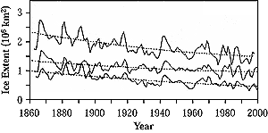
of Arctic sea-ice extent, using historical data from the past 135 years (Vinje,
2001), show that overall sea-ice extent in April has been reduced in the Nordic
seas by 0.79 x 10⁶ km2 (33%) (see Figure 16-3).
Nearly half of this reduction took place between 1860 and 1900. Although there
are large interannual and seasonal variations in sea-ice extent, the reduction
is greatest in spring. This is consistent with the 1912-1996 temperature record
from Svalbard, which shows significant warming (3°C) in spring (Hanssen-Bauer
and Forland, 1998). There is an approximate 10-year climate signal in the Arctic
and subarctic, with a clockwise propagating signal in sea-ice concentration
anomalies and a standing oscillation in sea-level pressure anomalies—the
latter linked to the two phases of the North Atlantic Oscillation (NAO) (Mysak
and Venegas, 1998). Comparison of these trends with outputs from climate models
(forced by observed GHGs and tropospheric sulfate aerosols) reveals that the
observed decrease in northern hemisphere sea-ice extent agrees with transient
simulations (see Figure 16-6) and that both trends
are much larger than would be expected from natural climate variations (Vinnikov
et al., 1999). Continues on next page |
 height="1" vspace="12">
|
Other reports in this collection |
height="5">