4.3.12. River Channel Form and Stability

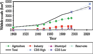
Figure 4-2: Global water withdrawals, 1900–1995, with projected
future total withdrawals to 2025 [data from Shiklomanov et al., 2000 (after
Raskin et al., 1997)]. |
Patterns of river channel erosion and sedimentation are
determined largely by variations in streamflow over time—in particular,
the frequency of floods. There is considerable literature on past changes in
streamflow—caused by human influences or natural climatic variability—and
associated river channel changes (Rumsby and Mackin, 1994) but very little on
possible future channel changes. This largely reflects a lack of numerical models
to simulate erosion and sedimentation processes; assessments of possible future
channel changes that have been made have been inferred from past changes. In
northern England, for example, Rumsby and Mackin (1994) show that periods with
large numbers of large floods are characterized by channel incision, whereas
periods with few floods were characterized by lateral reworking and sediment
transfer. Increased flooding in the future therefore could be associated with
increased channel erosion.
The density of the drainage network reflects the signature of climate on topography.
Moglen et al. (1998) show that drainage density is sensitive to climate change
but also that the direction of change in density depends not only on climate
change but also on the current climate regime.
Hanratty and Stefan (1998) simulated streamflow and sediment yield in a small
catchment in Minnesota. The scenario they used produced a reduction in sediment
yield, largely as a result of reduced soil erosion, but their confidence in
the model results was low. In fact, the lack of physically based models of river
channel form and sediment transport means that the confidence in estimates of
the effect of climate change on river channels is low in general.
4.3.13. Climate Change and Climatic Variability
Even in the absence of a human-induced climate change, hydrological behavior
will vary not only from year to year but also from decade to decade (see Section
4.2). Hulme et al. (1999) simulated streamflow across Europe under four
climate change scenarios for the 2050s (based on four different simulations
from the HadCM2 climate model) and seven scenarios representing different 30-year
climates extracted from a long run of the HadCM2 model with no GHG forcing.
They show that natural multi-decadal (30-year) variability in average annual
runoff is high across most of Europe and that this natural variability in runoff
in mid-latitude Europe is greater than the simulated signal of climate change.
In northern and southern Europe, the magnitude of climate change by the 2050s
is greater than the magnitude of natural variability. However, the spatial patterns
of climate change and climatic variability are very different, with a much more
coherent (usually north-south) pattern in the climate change signal. Nevertheless,
the results indicate that, for individual catchments in certain areas, the magnitude
of climate change effects on some indicators of streamflow may be smaller than
natural climatic variability for several decades, whereas in other areas, the
climate change signal will be larger than past experience.
|