11.1.2. Physical and Ecological Features
11.1.2.1. Regional Zonation
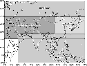
Figure 11-1: Geographical domain of Asia and its subregions. |
The Asian continent is bounded on the north by the Arctic
Ocean, on the east by the Pacific Ocean, and on the south by the Indian Ocean;
the western boundary, with Europe, runs roughly north-south along the eastern
Ural Mountains, the Zhem River, the Caspian Sea, the Kuma-Manych Depression,
the Black Sea, the Aegean Sea, the Mediterranean Sea, the Suez Canal, and the
Red Sea. The world's largest plateau—the Tibetan Plateau, with an
average elevation of more than 4,000 m—is located in Asia. Mt. Everest,
the highest peak in the world (8,848 m), lies near the southern border of this
plateau. The islands of Sri Lanka and Taiwan (China) and the archipelagoes of
Indonesia, the Philippines, and Japan also are part of Asia. Asia is the most
populous of the continents. Its total population in 1998 is estimated to be
about 3,589 million, of which almost 65% is rural. The coastline of Asia is
252,770 km long.
Based on broad climatic and geographical features, the Asian region can be
divided into four subregions: boreal Asia, arid and semi-arid Asia, temperate
Asia, and tropical Asia (Figure 11-1). This chapter discusses
key climatological, ecological, and socioeconomic features of each of these
subregions and the countries falling within them, as well as various aspects
of vulnerability, impacts, and adaptation in relation to climate change for
each of these regions.
Boreal Asia is located on the northern margins of the Eurasian continent between
50°N and the Arctic Circle. Boreal forests cover most of this region. Siberia,
which is a part of Russia (the main country in the region), has a mean monthly
temperature of about -50°C in January and is the coldest region of the northern
hemisphere in winter. Three Siberian rivers—the Ob, the Yenissey, and the
Lena—contribute about 42% of total runoff from all rivers of the Arctic
basin (CAFW, 1998). In the heart of this region is one of the world's largest
and oldest lakes, Baikal, the age of which is estimated to be about 25-30
million years (Kuzmin et al., 1997). Lake Baikal contains as much as 85% of
Russian surface freshwaters (Izrael et al., 1997a; Anokhin and Izrael, 2000).
There is evidence of recession of permafrost in recent decades (ICRF, 1998).
Arid and semi-arid Asia extends from 22°N to 50°N and from 30°E
to 105°E; it includes more than 20 countries of the Middle East and central
Asia. Many of the countries in the region are landlocked. Many storms develop
locally (in situ) over central Asia; some move into the region from the west.
The maximum frequency of cyclones occurs in January and March. Despite this
cyclonic activity, very little precipitation is recorded over most of the region
because of the lack of moisture. Most of the region has a precipitation-to-potential
evapotranspiration ratio of less than 0.45, which is typical of a semi-arid
and arid climate. Grasslands, rangelands, and deserts dominate most of arid
and semi-arid Asia.
Temperate Asia extends from 22°N to 50°N and from 105°E to 150°E;
it includes eastern China, the Japanese islands, the Korean peninsula, Mongolia,
and Taiwan (China). Geographically, the region is located on the eastern part
of the Eurasian continent— the world's largest continent—and
borders the Pacific, the world's largest ocean. The east-west distance
of the area is about 5,000 km; its north-south extent is about 3,000 km. Much
of the natural forest in the region has long been destroyed. Broad plains have
been cultivated and irrigated, and natural grasslands have been used for animal
husbandry for centuries.
Continues on next page
|