11.1.3.1. Surface Air Temperature
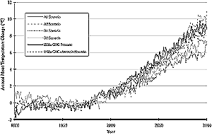
Figure 11-5: Future trends in area-averaged annual mean temperature
increase over land regions of Asia as simulated by CCSR/NIES AOGCM for IS92a
and SRES emission scenarios. Because the climate sensitivity of model versions
used for the new (SRES) and old (IS92a) sets of simulations are different,
temperature trends shown are scaled so they can be compared directly; trends
for IS92a scenarios are scaled by a factor of 1.56, which is the ratio of
climate sensitivity averaged over Asia of new model version to that of old
version. Also note that only the direct effect of sulfate aerosols is considered
in the IS92a GHG+Aerosols simulation, whereas the direct and indirect effects
of sulfate and carbon aerosols are considered in SRES simulations. |
Climate change scenarios that are based on an ensemble
of results as inferred from skilled AOGCMs for Asia and its subregions on annual
and seasonal mean basis are presented in Table 11-2. Three
future time periods centered around the 2020s (2010-2029), the 2050s (2040-2069),
and the 2080s (2070-2099) have been considered here for developing scenarios
of changes in surface air temperature and precipitation relative to the baseline
period of 1961-1990. The projected area-averaged annual mean warming is
1.6±0.2°C in the 2020s, 3.1±0.3°C in the 2050s, and 4.6±0.4°C
in the 2080s over land regions of Asia as a result of increases in the atmospheric
concentration of GHGs. Under the combined influence of GHGs and sulfate aerosols,
surface warming will be restricted to 1.4±0.3°C in the 2020s, 2.5±0.4°C
in the 2050s, and 3.8±0.5°C in the 2080s. In general, projected warming
over Asia is higher during NH winter than during summer for all time periods
(see also Giorgi and Francisco, 2000). The area-averaged increase in surface
air temperature is likely to be most pronounced over boreal Asia and least in
southeast Asia in all seasons (Lal and Harasawa, 2001). It is evident from Table
11-2 that even though aerosol forcing reduces surface warming, the magnitude
of projected warming is still considerable and could substantially impact the
Asian region.
In December 1998, the writing team for the IPCC Special Report on Emission
Scenarios (SRES) released a preliminary set of four SRES "marker"
scenarios: A1, A2, B1, and B2 (Nakicenovic et al., 1998). Scenario B1 projects
the most conservative future emissions of GHGs from Asia; scenario A2 is characteristic
of scenarios with higher rates of GHG emissions in combination with higher sulfate
and other aerosol emissions. The A1 scenario family has since been further divided
into three groups that describe alternative directions of technological change
in the energy system (IPCC, 2000). The three A1 groups are distinguished by
their technological emphasis: fossil fuel-intensive (A1FI), nonfossil energy
sources (A1T), or a balance across all sources (A1B). Projections of future
aerosol loading as envisaged in SRES marker scenarios are significantly lower
compared to the IS92a scenario.
Figure 11-5 illustrates the trends in area-averaged annual
mean surface air temperature increase over land regions of Asia as simulated
with CCSR/NIES AOGCMs for the IS92a scenario (GHG only and GHG + aerosols) and
for the new SRES "marker" emission scenarios. Projections of future
sulfate aerosol loading in SRES scenarios are significantly lower. Because the
treatment of aerosol and GHG radiative effects in the old and new sets of scenario
experiments is different, quantitative comparison of the results should be made
with care. Nonetheless, the generally higher projected surface warming trend
for SRES scenarios in the latter half of the 21st century is partially a result
of intensive reduction of aerosol emissions. Projected surface warming trends
for the IS92a and B1 emission pathways are close to each other. Maximum warming
is simulated for the A1 emission scenario during the first half of the 21st
century but is carried forward to the A2 emission scenario in the latter half
of the 21st century. Projections of regional climate change that use these newer
sets of emission scenarios for GHGs have not yet been thoroughly assessed for
their applications in impact assessment studies.
| Table 11-2: Plausible changes in area-averaged
surface air temperature (top) and precipitation (bottom) over Asia and its
subregions as a result of future increases in greenhouse gases (under IS92a
emission scenarios), as inferred from an ensemble of data generated in experiments
with CCSR/NIES, CSIRO, ECHAM4, and HadCM2 AOGCMs. Numbers in parentheses
are area-averaged changes when direct effects of sulfate aerosols are included. |
 |
| |
Precipitation Change (%) |
| |
2020s
|
2050s
|
2080s
|
| Regions |
Annual |
Winter |
Summer |
Annual |
Winter |
Summer |
Annual |
Winter |
Summer |
|
| Asia |
1.58
|
1.71
|
1.45
|
3.14
|
3.43
|
2.87
|
4.61
|
5.07
|
4.23
|
| |
(1.36)
|
(1.52)
|
(1.23)
|
(2.49)
|
(2.77)
|
(2.23)
|
(3.78)
|
(4.05)
|
(3.49)
|
|
| Boreal |
2.17
|
2.66
|
1.71
|
4.32
|
5.52
|
3.29
|
6.24
|
8.04
|
4.82
|
| |
(1.88)
|
(2.21)
|
(1.47)
|
(3.52)
|
(4.46)
|
(2.83)
|
(5.30)
|
(6.83)
|
(4.24)
|
| |
|
|
|
|
|
|
|
|
|
| Arid/Semi-Arid |
|
|
|
|
|
|
|
|
|
| - Central Asia |
1.61
|
1.56
|
1.77
|
3.18
|
2.81
|
3.55
|
4.83
|
4.41
|
5.34
|
| |
(1.47)
|
(1.55)
|
(1.49)
|
(2.69)
|
(2.61)
|
(2.59)
|
(4.15)
|
(3.78)
|
(4.36)
|
| - Tibet |
1.77
|
1.90
|
1.62
|
3.38
|
3.55
|
3.19
|
5.04
|
5.39
|
4.69
|
| |
(1.56)
|
(1.83)
|
(1.40)
|
(2.62)
|
(2.94)
|
(2.27)
|
(4.06)
|
(4.32)
|
(3.73)
|
| |
|
|
|
|
|
|
|
|
|
| Temperate |
1.49
|
1.74
|
1.23
|
2.86
|
3.26
|
2.48
|
4.34
|
5.11
|
3.67
|
| |
(1.19)
|
(1.50)
|
(0.99)
|
(2.10)
|
(2.40)
|
(1.72)
|
(3.31)
|
(3.83)
|
(2.77)
|
| |
|
|
|
|
|
|
|
|
|
| Tropical |
|
|
|
|
|
|
|
|
|
| - South Asia |
1.36
|
1.62
|
1.13
|
2.69
|
3.25
|
2.19
|
3.84
|
4.52
|
3.20
|
| |
(1.06)
|
(1.19)
|
(0.97)
|
(1.92)
|
(2.08)
|
(1.81)
|
(2.98)
|
(3.25)
|
(2.67)
|
| - SE Asia |
1.05
|
1.12
|
1.01
|
2.15
|
2.28
|
2.01
|
3.03
|
3.23
|
2.82
|
| |
(0.96)
|
(0.94)
|
(0.96)
|
(1.72)
|
(1.73)
|
(1.61)
|
(2.49)
|
(2.51)
|
(2.34)
|
|
| |
Precipitation Change (%) |
| |
2020s
|
2050s
|
2080s
|
| Regions |
Annual |
Winter |
Summer |
Annual |
Winter |
Summer |
Annual |
Winter |
Summer |
|
| Asia |
3.6
|
5.6
|
2.4
|
7.1
|
10.9
|
4.1
|
11.3
|
18.0
|
5.5
|
| |
(2.3)
|
(4.3)
|
(1.8)
|
(2.9)
|
(6.5)
|
(1.5)
|
(7.0)
|
(12.1)
|
(3.5)
|
|
| Boreal |
6.1
|
11.1
|
2.6
|
12.8
|
23.8
|
5.1
|
20.7
|
39.5
|
7.7
|
| |
(6.7)
|
(10.7)
|
(3.3)
|
(12.0)
|
(19.7)
|
(7.1)
|
(18.9)
|
(31.5)
|
(10.3)
|
| |
|
|
|
|
|
|
|
|
|
| Arid/Semi-Arid |
|
|
|
|
|
|
|
|
|
| - Central Asia |
1.3
|
3.0
|
-2.1
|
1.3
|
6.9
|
-2.3
|
-1.3
|
6.9
|
-4.0
|
| |
(1.1)
|
(2.7)
|
(5.9)
|
(0.6)
|
(1.4)
|
(0.7)
|
(-3.6)
|
(1.0)
|
(-1.8)
|
| - Tibet |
5.9
|
8.9
|
4.4
|
9.0
|
19.2
|
4.7
|
12.8
|
25.6
|
5.7
|
| |
(3.4)
|
(7.4)
|
(1.7)
|
(7.5)
|
(14.8)
|
(1.7)
|
(11.5)
|
(18.8)
|
(3.8)
|
| |
|
|
|
|
|
|
|
|
|
| Temperate |
3.9
|
4.2
|
3.7
|
7.9
|
13.3
|
5.4
|
10.9
|
20.1
|
7.8
|
| |
(0.9)
|
(0.4)
|
(1.2)
|
(1.3)
|
(4.3)
|
(0.7)
|
(4.8)
|
(7.1)
|
(3.1)
|
| |
|
|
|
|
|
|
|
|
|
| Tropical |
|
|
|
|
|
|
|
|
|
| - South Asia |
2.9
|
2.7
|
2.5
|
6.8
|
-2.1
|
6.6
|
11.0
|
5.3
|
7.9
|
| |
(1.0)
|
(-10.1)
|
(2.8)
|
(-2.4)
|
(-14.8)
|
(0.1)
|
(-0.1)
|
(-11.2)
|
(2.5)
|
| - SE Asia |
2.4
|
1.4
|
2.1
|
4.6
|
3.5
|
3.4
|
8.5
|
7.3
|
6.1
|
| |
(1.7)
|
(3.3)
|
(1.2)
|
(1.0)
|
(2.9)
|
(2.6)
|
(5.1)
|
(5.9)
|
(4.9)
|
|
|