11.1.3.4. High-Resolution Climate Change Experiments

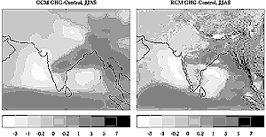
Figure 11-7: Spatial distribution of changes in monsoon rainfall
over Indian subcontinent as simulated by Hadley Centre's global and
regional climate models at the time of doubling of CO2 in the
atmosphere. |
Although these AOGCMs treat the complex interactions of
atmospheric physics and planetary-scale dynamics fairly well, coarse horizontal
resolution in the models restricts realistic simulation of climatic details
on spatial variability. For example, tropical precipitation has high temporal
and spatial variability, which cannot be resolved realistically in currently
available AOGCMs. Many investigations on the ability of GCMs to simulate the
Asian monsoon have been reported in the literature (e.g., Meehl and Washington,
1993; Chakraborty and Lal, 1994; Bhaskaran et al., 1995; Lal et al., 1995a,
1997, 1998a,b). These studies suggest that although most GCMs are able to simulate
the large-scale monsoon circulation well, generally they are less successful
with the summer monsoon rainfall. Since the SAR, nested modeling approaches
have been followed to generate high-resolution regional climate scenarios (Jones
et al., 1995; Lal et al., 1998c; Hassell and Jones, 1999) with more realistic
mesoscale details and the response of GHG forcings to the surface climatology
over the Asian monsoon region.
Large-scale patterns of temperature change simulated by GCMs and nested regional
climate models (RCMs) are found to be generally similar under 2xCO2
forcing, but the regional model results present some additional details associated
with coastline and local topographical features (Hirakuchi and Giorgi, 1995).
In addition, projected warming over eastern China region in the summer is less
pronounced in the RCM than in the GCM and is characterized by a different spatial
pattern. This is related to an increase in monsoon precipitation simulated by
the RCM there and associated surface cooling induced by evaporation and cloudiness.
Nonetheless, the GCM and RCM simulations suggest a general increase in warming
toward higher latitudes and greater warming in winter than in summer. The RCM
produces a more pronounced increase in winter precipitation over southeastern
China than does the GCM in response to orographic lifting of stronger low-level
southerly onshore winds. The RCM also simulates increased precipitation in the
monsoon rain belt over east China, Korea, and Japan during the summer.
The increase in surface air temperature simulated by the RCM over central and
northern India is not as intense as in the GCM and does not extend as far south
(Lal et al., 1998c; Hassell and Jones, 1999). These anomalies are linked with
changes in surface hydrological variables. Summer precipitation exhibits a more
complex pattern of increases and decreases. Whereas an increase in rainfall
is simulated over the eastern region of India, northwestern deserts see a small
decrease in the absolute amount of rainfall in RCM simulation (Figure
11-7). Changes in soil moisture broadly follow those in precipitation except
in eastern India, where they decrease as a result of enhanced drainage from
the soil. The largest reductions (precipitation reduced to <1 mm day-1; 60%
decline in soil moisture) are simulated in the arid regions of northwest India
and Pakistan. The projected increase in precipitation in flood-prone Bangladesh
is approximately 20%. Nested RCM simulations have the potential to simulate
the onset of the summer monsoon and its active/break cycle over India. The RCM
captures the observed precipitation maximum over the southern tip of India during
weak monsoon conditions, whereas the GCM does not.
Given the current state of climate modeling, projections of future regional
climate have only limited confidence. The degree of confidence that could be
attributed to RCM responses in terms of temporal and spatial changes resulting
from GHG forcings would depend on more accurate simulation of the space and
time evolution of large-scale monsoon circulation features in AOGCMs, as well
as additional long-term RCM simulations with better skill. Current efforts on
climate variability and climate change studies increasingly rely on diurnal,
seasonal, latitudinal, and vertical patterns of temperature trends to provide
evidence for anthropogenic signatures. Such approaches require increasingly
detailed understanding of the spatial variability of all forcing mechanisms
and their connections to global, hemispheric, and regional responses. Because
the anthropogenic aerosol burden in the troposphere would have large spatial
and temporal variations in the atmosphere, its future impact on regional scale
would be in striking contrast to the impact from GHGs. It has also been suggested
that aerosols produced by tropical biomass burning could lead to additional
negative radiative forcing (Portmann et al., 1997). Considerable uncertainty
prevails about the indirect effect of aerosols on tropospheric clouds, which
could strongly modulate the climate. The implications of localized radiative
forcing on deep convection in tropical Asia and on Hadley circulation are still
not understood (Lal et al., 2000).
|