|
|
 |
 |
 |
 |
|
IPCC Fourth Assessment Report: Climate Change 2007 |
|
 |
|
 |
|
|
Climate Change 2007: Working Group I: The Physical Science Basis 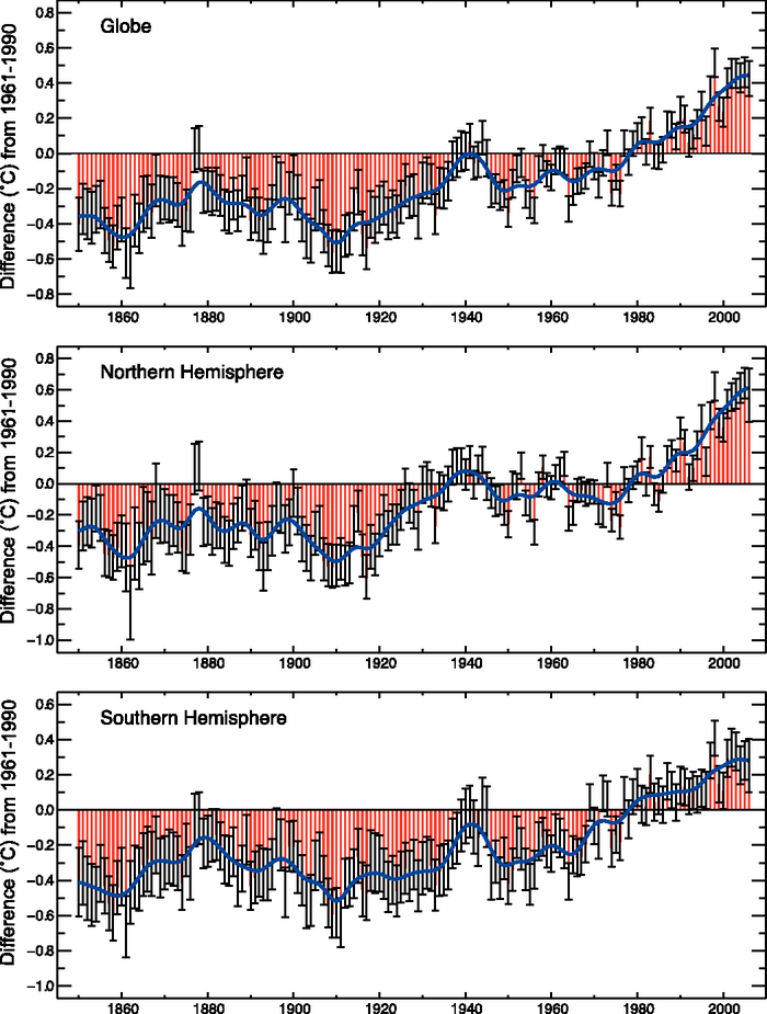 3.6Box 3.6: Recent Extreme Events Single extreme events cannot be simply and directly attributed to anthropogenic climate change, as there is always a finite chance the event in question might have occurred naturally. However, when a pattern of extreme weather persists for some time, it may be classed as an extreme climate event, perhaps associated with anomalies in SSTs (such as El Niño). This box provides examples of some recent (post-TAR) notable extreme climate events. A lack of long and homogeneous observational data often makes it difficult to place some of these events in a longer-term context. The odds may have shifted to make some of them more likely than in an unchanging climate, but attribution of the change in odds typically requires extensive model experiments, a topic taken up in Chapter 9. It may be possible, however, to say that the occurrence of recent events is consistent with physically based expectations arising from climate change. Some examples of these recent events are described below (in response to the questions posed to IPCC by the governments) and placed in a long-term perspective. Drought in Central and Southwest Asia, 1998–2003 Between 1999 and 2003 a severe drought hit much of southwest Asia, including Afghanistan, Kyrgyzstan, Iran, Iraq, Pakistan, Tajikistan, Turkmenistan, Uzbekistan and parts of Kazakhstan (Waple and Lawrimore, 2003; Levinson and Waple, 2004). Most of the area is a semiarid steppe, receiving precipitation only during winter and early spring through orographic capture of eastward- propagating mid-latitude cyclones from the Atlantic Ocean and the Mediterranean Sea (Martyn, 1992). Precipitation between 1998 and 2001 was on average less than 55% of the long-term average, making the drought conditions in 2000 the worst in 50 years (Waple et al., 2002). By June 2000, some parts of Iran had reported no measurable rainfall for 30 consecutive months. In December 2001 and January 2002, snowfall at higher altitudes brought relief for some areas, although the combination of above-average temperatures and early snowmelt, substantial rainfall and hardened ground desiccated by prolonged drought resulted in flash flooding during spring in parts of central and southern Iran, northern Afghanistan and Tajikistan. Other regions in the area continued to experience drought through 2004 (Levinson, 2005). In these years, an anomalous ridge in the upper-level circulation was a persistent feature during the cold season in central and southern Asia. The pattern served to both inhibit the development of baroclinic storm systems and deflect eastward-propagating storms to the north of the drought-affected area. Hoerling and Kumar (2003) linked the drought in certain areas of the mid-latitudes to common global oceanic influences. Both the prolonged duration of the 1998–2002 cold phase ENSO (La Niña) event and the unusually warm ocean waters in the western Pacific and eastern Indian Oceans appear to contribute to the severity of the drought (Nazemosadat and Cordery, 2000; Barlow et al., 2002; Nazemosadat and Ghasemi, 2004). Drought in Australia, 2002–2003 A severe drought affected Australia during 2002, associated with a moderate El Niño event (Watkins, 2002). However, droughts in 1994 and 1982 were about as dry as the 2002 drought. Earlier droughts in the first half of the 20th century may well have been even drier. The 2002 drought came after several years of good rainfall (averaged across the country), rather than during an extended period of low rainfall such as occurred in the 1940s. If only rainfall is considered, the 2002 drought alone does not provide evidence of Australian droughts becoming more extreme. However, daytime temperatures during the 2002 drought were much higher than during previous droughts. The mean annual maximum temperature for 2002 was 0.5°C warmer than in 1994 and 1.0°C warmer than in 1982. So in this sense, the 2002 drought and associated heat waves were more extreme than the earlier droughts, because the impact of the low rainfall was exacerbated by high potential evaporation (Karoly et al., 2003; Nicholls, 2004). The very high maximum temperatures during 2002 could not simply be attributed to the low rainfall, although there is a strong negative correlation between rainfall and maximum temperature. Severe long-term drought, stemming from at least three years of rainfall deficits, continued during 2005, especially in the eastern third of Australia, although above-normal rainfall in winter and spring 2005 brought some relief. These conditions also have been accompanied by record high maximum temperatures over Australia during 2005 (a comparable national series is only available since 1951). Drought in Western North America, 1999–2004 The western USA, southern Canada and northwest Mexico experienced a recent pervasive drought (Lawrimore et al., 2002), with dry conditions commencing as early as 1999 and persisting through the end of 2004 (Box 3.6, Figure 1). Drought conditions were recorded by several hydrologic measures, including precipitation, streamflow, lake and reservoir levels and soil moisture (Piechota et al., 2004). The period 2000 through 2004 was the first instance of five consecutive years of below-average flow in the Colorado River since the beginning of modern records in 1922 (Pagano et al., 2004). Cook et al. (2004) provided a longer-term context for this drought. In the western conterminous USA, the area under moderate to extreme drought, as given by the PDSI, rose above 20% in November 1999 and stayed above this level persistently until October 2004. At its peak (August 2002), this drought affected 87% of the West (Rocky Mountains westward), making it the second most extensive and one of the longest droughts in the last 105 years. The impacts of this drought have been exacerbated by depleted or earlier than average melting of the mountain snowpack, due to warm springs, as observed changes in timing from 1948 to 2000 trended earlier by one to two weeks in many parts of the West (Cayan et al., 2001; Regonda et al., 2005; Stewart et al., 2005). Within this episode, the spring of 2004 was unusually warm and dry, resulting in record early snowmelt in several western watersheds (Pagano et al., 2004). Hoerling and Kumar (2003) attributed the drought to changes in atmospheric circulation associated with warming of the western tropical Pacific and Indian oceans, while McCabe et al. (2004) have produced evidence suggesting that the confluence of both Pacific decadal and Atlantic multi-decadal fluctuations is involved. In the northern winter of 2004 to 2005, the weak El Niño was part of a radical change in atmospheric circulation and storm track across the USA, ameliorating the drought in the Southwest, although lakes remain low. Floods in Europe, Summer 2002 A catastrophic flood occurred along several central European rivers in August 2002. The floods resulting from extraordinarily high precipitation were enhanced by the fact that the soils were completely saturated and the river water levels were already high because of previous rain (Rudolf and Rapp, 2003; Ulbrich et al., 2003a,b). Hence, it was part of a pattern of weather over an extended period. In the flood, the water levels of the Elbe at Dresden reached a maximum mark of 9.4 m, which is the highest level since records began in 1275 (Ulbrich et al., 2003a). Some small villages in the Ore Mountains (on tributaries of the Elbe) were hit by extraordinary flash floods. The river Vltava inundated the city of Prague before contributing to the Elbe flood. A return period of 500 years was estimated for the flood levels at Prague (Grollmann and Simon, 2002). The central European floods were caused by two heavy precipitation episodes. The first, on 6–7 August, was situated mainly over Lower Austria, the southwestern part of the Czech Republic and southeastern Germany. The second took place on 11–13 August 2002 and most severely affected the Ore Mountains and western parts of the Czech Republic. A persistent low-pressure system moved slowly from the Mediterranean Sea to central Europe on a path over or near the eastern Alps and led to large-scale, strong and quasi-stationary frontal lifting of air with very high liquid water content. Additional to this advective rain were convective precipitation processes (showers and thunderstorms) and a significant orographic lifting (mainly over the Ore Mountains). A maximum 24-hour precipitation total of 353 mm was observed at the German station Zinnwald-Georgenfeld, a new record for Germany. The synoptic situation leading to floods is well known to meteorologists of the region. Similar situations led to the summer floods of the River Oder in 1997 and the River Vistula in 2001 (Ulbrich et al., 2003b). Average summer precipitation trends in the region are negative but barely significant (Schönwiese and Rapp, 1997) and there is no significant trend in flood occurrences of the Elbe within the last 500 years (Mudelsee et al., 2003). However, the observed increase in precipitation variability at a majority of German precipitation stations during the last century (Trömel and Schönwiese, 2005) is indicative of an enhancement of the probability of both floods and droughts. Heat Wave in Europe, Summer 2003 The heat wave that affected many parts of Europe during the course of summer 2003 produced record-breaking temperatures particularly during June and August (Beniston, 2004; Schär et al., 2004; see Box 3.6, Figure 2). Absolute maximum temperatures exceeded the record highest temperatures observed in the 1940s and early 1950s in many locations in France, Germany, Switzerland, Spain, Italy and the UK, according to the information supplied by national weather agencies (WMO, 2004). Gridded instrumental temperatures (from CRUTEM2v for the region 35°N–50°N, 0–20°E) show that the summer was the hottest since comparable records began in 1780: 3.8°C above the 1961 to 1990 average and 1.4°C hotter than any other summer in this period (the second hottest was 1807). Based on early documentary records, Luterbacher et al. (2004) estimated that 2003 is very likely to have been the hottest summer since at least 1500. The 2003 heat wave was associated with a very robust and persistent blocking high-pressure system that may be a manifestation of an exceptional northward extension of the Hadley Cell (Black et al., 2004; Fink et al., 2004). Already a record month in terms of maximum temperatures, June exhibited high geopotential values that penetrated northwards towards the British Isles, with thegreatest northward extension and longest persistence of record-high temperatures observed in August. An exacerbating factor for the temperature extremes was the lack of precipitation in many parts of western and central Europe, leading to much-reduced soil moisture and surface evaporation and evapotranspiration, and thus to a strong positive feedback effect (Beniston and Diaz, 2004). The 2005 Tropical Storm Season in the North Atlantic The 2005 North Atlantic hurricane season (1 June to 30 November) was the most active on record by several measures, surpassing the very active season of 2004 (e.g., Levinson, 2005) and causing an unprecedented level of damage. Even before the peak in the seasonal activity, the seven tropical storms in June and July were the most ever, and hurricane Dennis was the strongest on record in July and the earliest ever fourth-named storm. The record 2005 North Atlantic hurricane season featured the largest number of named storms (28; sustained winds greater than 17 m s–1) and is the only time names have ventured into the Greek alphabet. It had the largest number of hurricanes (15; sustained winds greater than 33 m s–1) recorded, and is the only time there have been four category 5 storms (maximum sustained winds greater than 67 m s–1). These included the most intense Atlantic storm on record (Wilma, with recorded surface pressure in the eye of 882 hPa), the most intense storm in the Gulf of Mexico (Rita, 897 hPa), and Katrina. Tropical storm Vince was the first ever to make landfall in Portugal and Spain. In spite of these metrics, the ACE index, although very high and surpassing the 2004 value (Figure 3.40), was not the highest on record, as several storms were quite short lived. Six of the eight most damaging storms on record for the USA occurred from August 2004 to September 2005 (Charlie, Ivan, Francis, Katrina, Rita, Wilma) while another storm in 2005 (Stan) caused severe flooding and mudslides as well as about 2,000 fatalities in central America (Guatemala, El Salvador and southern Mexico). SSTs in the tropical North Atlantic region critical for hurricanes (10°N to 20°N) were at record-high levels (0.9°C above the 1901 to 1970 normal ) in the extended summer (June to October) of 2005 (Figure 3.33), and these high values were a major reason for the very active hurricane season along with favourable atmospheric conditions (see Box 3.5). A substantial component of this warming was the global mean SST increase (Trenberth and Shea, 2006; see Sections 3.2 and 3.6.6). |
|
|
|