|
5.4.4. Precision and Costs
Field methods to accurately quantify carbon pools exist, but the level of precision
can vary by pool. The total error in measuring a given carbon pool is based
on sampling error (variation among sampling units-e.g., the number of plots,
within the population of interest), measurement error (error in measuring the
parameter of interest-e.g., stem diameter and soil carbon) and regression error,
when appropriate (e.g., error resulting from conversion of tree diameter to
biomass based on a regression equation). Sampling error is usually the largest
source of error (Phillips et al., 2000), and increased precision generally
comes at increased costs of inventorying because of the time and cost involved
in establishing the appropriate number and distribution of permanent plots.
Carbon inventory in forests can be more complicated than traditional forest
inventories because each carbon pool will have a different variance. The sample
size for each pool can be calculated individually; based on resources available
for monitoring the project and the information in Table
5-7, informed decisions can be made about which pools to measure and count.
Such information can be used at the design stage to select pools to be included
in the project, with significant implications for the total cost of the project
and the measurement and monitoring costs per ton of carbon.
The costs of measuring and monitoring carbon offsets are a function mainly
of the desired level of precision-which may vary by the type of project activities,
the size of the project (areal extent, as well as whether the project area is
contiguous or a dispersed bundle of small landowners), and the natural variation
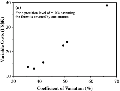
within the various carbon pools. For example, an increase in the coefficient
of variation (a measure of the variation around the mean) within a forest stratum
of about 160 percent would increase the cost of measurement by about 280 percent
to maintain the same level of precision (Figure 5-6a).
Stratification of the project area into more or less homogeneous units-based
on vegetation type, soil type, topography or management practice-can increase
the precision of carbon measurements without increasing the cost unduly by lowering
the amount of variation around the mean, thereby requiring fewer plots to be
within acceptable levels of precision.
|
|
|
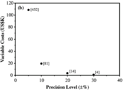
Figure 5-6: Relationship between (a) coefficient
of variation and (b) level of precision and total variable costs for
the first inventory phase of the Noel Kempff Climate Action Project
in Bolivia (data from Powell, 1999).
|
A few data provide some preliminary estimates of costs for measuring and monitoring
of carbon in LULUCF projects in three tropical countries (Powell, 1999; Subak,
2000; Box 5-4). For the first inventory of the NKCAP, the total fixed operational
costs (including human resource costs, project management, mapping, and so forth)
were estimated to be about $196,000; variable costs (including labor, equipment,
transport, and so forth) ranged between $230 and $281 per plot and totaled about
$154,000 (625 plots). The grand total cost was about $350,000 (Powell, 1999).
The precision of the inventory, based on sampling error only, was ±4 percent
with 95-percent confidence (see Box 5-3). The variable
costs dropped rapidly from about $108,000 for a precision level of ±5 percent
to $1,000 for a level of ±30 percent; fixed costs would be the same for all
levels of precision (Figure 5-6b). Estimates of the
revised carbon benefits from this project for its duration based on additional
measurements and data collection (Brown et al., 2000) and the additional
cost to collect this information result in an estimate of about $0.10 per t
C. Estimating future monitoring costs based on the first inventory is difficult,
but they are likely to be less than those for the initial inventory because
different sampling intensities will be used, project implementers can build
on previous experience, and advances in technology will be available (see, e.g.,
Section 5.4.3).
|
Box 5-4. Cost of Monitoring and Verification of a
Forest-Based Project in the Western Ghats, India
|
| The dominant activity in this project is to reforest degraded lands.
The specifics are to perform enrichment planting of trees in partially
degraded forests and establish multi-purpose tree plantations on fully
degraded lands (Ravindranath and Bhat, 1997). The carbon benefits from
this project are from carbon conservation of biomass in native forest
by substituting with wood from tree plantations, carbon sequestration
in trees and soil in the enrichment planting of partially degraded forests
(logging is banned in this area), and enhancing soils carbon in the badly
degraded lands. The total area to be reforested is 42,000 ha, with a total
budget of US$11.7 million over a period of six years starting in 1991.
The cost of reforesting with the dominant multi-purpose tree plantations
is US$609 ha-1. The allocation for monitoring and research of the reforested
lands (survival and growth rate) is about US$1 million, which accounts
for about 9 percent of the total budget allocated for this project (Ravindranath
and Bhat, 1997). The annual cost for monitoring of the project lands is
about US$5 ha-1. |
The organization responsible for monitoring carbon sequestration in Costa Rica's
Private Forestry Project and for acquiring remote-sensing information has an
annual budget of $200,000 (Subak, 2000). Additional costs associated with the
PFP relate to the costs of monitoring forests and plantations. The implementing
organizations do not absorb all of the monitoring costs: They charge landowners
at a rate that varies in different regions. In the Central Volcanic Range (including
the upper Virilla), for example, landowners pay implementing organizations 10
percent of their annual environmental services payment for monitoring of forest
protection and slightly more for monitoring of forest management but do not
pay anything for monitoring of plantations (Subak, 2000). The implementing agency's
unit costs will tend to be higher when monitoring of smaller landholdings, and
although a stated objective of the PFP is to compensate small and medium-sized
landowners, some implementers may favor larger parcels. Monitoring of the PFP
is supposed to include site visits by forest engineers as well as more detailed
audits of some sites. The annual visits involve making a report on the size,
density, and health of the trees on the land; the more detailed audits are to
assess management as well as the conditions of the trees and soil. The intention
is to audit as few as 5 percent of the PFP sites. The labor costs for auditing
are estimated to be $10 ha-1 yr-1-compared to $1 ha-1 yr-1 for monitoring and
$2 ha-1 yr-1 for certification. The aggregate costs of project development,
recruiting, and auditing are significant, but they have not been judged to be
excessive or to reverse the cost-effectiveness of the PFP as an LULUCF project.
Currently, there are no guidelines regarding the level of precision to which
pools should be measured and monitored. Setting such a level would facilitate
comparison of projects and could encourage project developers to measure projects
more precisely if the price of carbon was high. If the total average carbon
benefit was 5 million t C with a ±30-percent confidence interval, for example,
the lower bound carbon benefit would be 3.5 million t C. If LULUCF projects
could only claim benefits for a lower bound of the confidence interval and if
carbon was worth $10 per t C, the "loss" of carbon benefits would be 1.5 million
tons-equivalent to $15 million, a value likely to greatly exceed the cost of
monitoring to a ±5-percent precision level. Thus, project developers would probably
chose high precision levels for their monitoring.
|