| Working Group I: The Scientific Basis |
| Working Group I: The Scientific Basis |
|
|
|
| Other reports in this collection | |
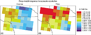
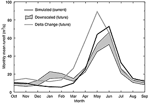
13.4.1.1 Regional modellingThe basic strategy in regional modelling is to rely on the GCM to reproduce the large-scale circulation of the atmosphere and for the regional model to simulate sub-GCM scale regional distributions or patterns of climate, such as precipitation, temperature, and winds, over the region of interest (Giorgi and Mearns, 1991; McGregor, 1997; Giorgi and Mearns, 1999). The GCM provides the initial and lateral boundary conditions for driving the regional climate model (RCM). In general, the spatial resolution of the regional model is on the order of tens of kiilometres, whereas the GCM scale is an order of magnitude coarser. Further details on the techniques of regional climate modelling are covered in Chapter 10, Section 10.5. 13.4.1.2 Statistical downscalingIn statistical downscaling, a cross-scale statistical relationship is developed between large-scale variables of observed climate such as spatially averaged 500 hPa heights, or measure of vorticity, and local variables such as site-specific temperature and precipitation (von Storch, 1995; Wilby and Wigley, 1997; Murphy, 1999). These relationships are assumed to remain constant in the climate change context. Also, it is assumed that the predictors selected (i.e., the large-scale variables) adequately represent the climate change signal for the predictand (e.g., local-scale precipitation). The statistical relationship is used in conjunction with the change in the large-scale variables to determine the future local climate. Further details of these techniques are provided in Chapter 10, Section 10.6. 13.4.1.3 Applications of the methods to impactsWhile the two major techniques described above have been available for about ten years, and proponents claim use in impact assessments as one of their important applications, it is only quite recently that scenarios developed using these techniques have actually been applied in a variety of impact assessments, such as temperature extremes (Hennessy et al., 1998; Mearns, 1999); water resources (Hassall and Associates, 1998; Hay et al., 1999; Wang et al., 1999; Wilby et al., 1999; Stone et al., 2001); agriculture (Mearns et al., 1998, 1999, 2000a, 2001; Brown et al., 2000) and forest fires (Wotton et al., 1998). Prior to the past couple of years, these techniques were mainly used in pilot studies focused on increasing the temporal (and spatial) scale of scenarios (e.g., Mearns et al., 1997; Semenov and Barrow, 1997). One of the most important aspects of this work is determining whether the high resolution scenario actually leads to significantly different calculations of impacts compared to that of the coarser resolution GCM from which the high resolution scenario was partially derived. This aspect is related to the issue of uncertainty in climate scenarios (see Section 13.5). We provide examples of such studies below. Application of high resolution scenarios produced from a regional model (Giorgi et al., 1998) over the Central Plains of the USA produced changes in simulated crop yields that were significantly different from those changes calculated from a coarser resolution GCM scenario (Mearns et al., 1998; 1999, 2001). For simulated corn in Iowa, for example, the large-scale (GCM) scenario resulted in a statistically significant decrease in yield, but the high resolution scenario produced an insignificant increase (Figure 13.5). Substantial differences in regional economic impacts based on GCM and RCM scenarios were also found in a recent integrated assessment of agriculture in the south-eastern USA (Mearns et al., 2000a,b). Hay et al. (1999), using a regression-based statistical downscaling technique, developed downscaled scenarios based on the Hadley Centre Coupled AOGCM (HadCM2) transient runs and applied them to a hydrologic model in three river basins in the USA. They found that the standard scenario from the GCM produced changes in surface runoff that were quite different from those produced from the downscaled scenario (Figure 13.6). |
|
Other reports in this collection |