15.3.2. Subregional and Extra-Regional Cases
15.3.2.1. Introduction
The discussion that follows offers a sample of subregional and extra-regional
cases that reflect the unique and changing nature of the relationship between
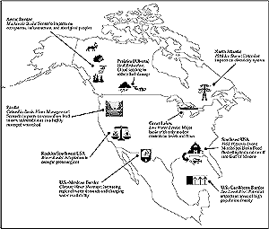
climate and places in the North American context. Six subregions have been defined:
Pacific, Rocky Mountains-Southwest United States, Prairies-Great Plains,
Great Lakes-St. Lawrence, North Atlantic, and Southeast United States (see
Figure 15-9). These subregions represent unique landscapes
that have experienced development paths that reflect natural potential for resource
development as well as region-specific histories of evolving economies and communities.
Some of these cases describe responses to recent extreme events. Others focus
on scenarios of future climatic changes. Canada and the United States have a
long history of cooperating on resource management concerns in transboundary
areas, including the Boundary Waters Treaty of 1909 and more recent agreements
on transboundary air pollution, watershed development, and the environmental
agreement associated with NAFTA. There also have been binational and subregional
conflicts over a wide range of issues that are climate-sensitive, including
water resources, wetland protection, trading of forest and agricultural commodities,
and harvesting of transboundary fish stocks. Various cooperative management
approaches are being considered. Could climate change make a difference in any
of these conflicts? Extra-regional issues are considered for the Arctic, U.S.-Mexican,
and U.S.-Caribbean borders.

Figure 15-9: Subregional cases from North America (described in Section
15.3.2). |

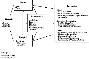
Figure 15-10: Research framework for MBIS (Cohen, 1997b). Scenarios
were generated for use by physical and biological system studies. Socioeconomic
component used results from these assessments, as well as climate scenario
information where appropriate. Integration exercises were based on outputs
from sectoral studies. |
15.3.2.2. Pacific Subregion
This subregion includes the Columbia River basin—the fourth-largest in
North America, and one of the most valuable and heavily developed watersheds.
The Columbia system produces 18,500 MW of hydroelectricity; it also is managed
for flood control, agriculture, navigation, sport and commercial fisheries,
log transportation, recreation, wildlife habitat, and urban, industrial, and
aboriginal uses. Climate variability affects the total volume and temporal pattern
of natural runoff, although binational management agreements have substantially
altered this pattern. Any hydrological changes caused by long-term climatic
change will have impacts that may affect the management of the system and the
nature of conflicts among various users. Recent management and policy changes
have led to changes in system operations; fish habitat protection now is regarded
as a high priority—on par with hydroelectricity production and flood control
(Cohen et al., 2000).
Climatic change is expected to lead to reductions in annual streamflow. Estimates
for three warming scenarios range from a small increase to a decrease of 16%
by 2050, with an earlier annual peak, higher winter flows, and lower summer
flows (Lettenmaier et al., 1996, 1999; Hamlet and Lettenmaier, 1999;
Miles et al., 2000). This would affect system reliability. Results from
a reservoir system model for the driest of the three scenarios [based on the
Max Planck Institute (MPI) GCM, ECHAM-4] indicate reductions of 15% in reliability
for Snake River irrigation, 11% for McNary Dam "biological flow" (to
support fish habitat), 14% for firm energy production, and 19% for nonfirm energy
production. Reliability for flood control would remain relatively unchanged
in this case but would decrease in the wetter scenarios (Hamlet and Lettenmaier,
1999; Miles et al., 2000).
Interviews were held in 1997 with water resources managers and other stakeholders
in the upstream portion of the Columbia, on the Canadian side. Their responses
to the MPI scenario were similar to those obtained from the reservoir system
model. For example, they noted that flood risk would not necessarily be reduced
because upstream storage facilities may be releasing high discharges for fish
habitat protection or other reasons. Similarly, irrigation supply and hydroelectricity
production would be reduced because of lower annual flow combined with fish
protection requirements. In these circumstances, regional utilities might have
to purchase electricity from fossil fuel sources, thereby affecting the region's
ability to meet GHG emission targets (Cohen et al., 2000).
This case study suggests that despite the high level of development and management
in the Columbia basin, vulnerabilities would still exist and impacts could still
occur in scenarios of natural streamflow changes caused by global climate change.
It also suggests that expanded development of hydroelectric facilities, as a
means of reducing GHG emissions, will create considerable challenges to management,
given increases in the sensitivity of regional energy supplies and other water-related
resources to climate.
|