2.2.2.1. Types of Forest Definitions
There are three broad categories of forest definition: administrative, land
use, and land cover.
Administrative. Forests have been defined in terms of legal or administrative
requirements. Typical examples follow: "Any lands falling within the jurisdiction
of the Department of XYZ" or "any lands so mapped in the ordinance survey of
XYZ." These definitions bear no relationship to the vegetation characteristics
and associated carbon on that land. For this reason, definitions of deforestation
and reforestation that are based on administrative or legal definitions of forests
may not provide as full a picture of changes in carbon stocks as some of the
alternatives discussed below. Nevertheless, many national statistics are based
on such definitions. This situation may lead to a confounding of information
on forests with that for other vegetation types.
Land use. Another set of definitions defines forests in terms of land
use. A typical example follows: "An area managed for the production of timber
and other forest products or maintained as woody vegetation for such indirect
benefits as protection of catchment areas or recreation." Some definitions incorporate
an element of potential or even desirable land use, such as that in the Swedish
Forest Act of 1994: "For the purposes of this Act, forest land is defined as:
(i) land which is suitable for wood production, and not used to a significant
extent for other purposes; and (ii) land where tree cover is desirable in order
to protect against sand or soil erosion, or to prevent a lowering of the tree
line. Land that is wholly or partially unused shall not be regarded as forest
land if, due to special conditions, it is not desirable that this land be used
for wood production." Many definitions explicitly include areas that are temporarily
not covered by large trees (e.g., stands of seedlings that are regrowing after
clear-felling or disturbance) or small, included, non-treed areas (e.g., roads
and other infrastructure). Again, these definitions may fail to reflect land
cover. Treed areas used for purposes other than the forest land-use definition,
such as grazed woodlands, may be excluded-along with their substantial carbon
pools.
Finding a universally applicable definition of forest based on land use will
be difficult. Such definitions may be related simply to the intent of management;
they may require at least a minimum amount of management, or they may require
frequent and intensive management.
Land cover. The third category defines a forest in terms of vegetative
land cover. An example follows: "An ecosystem characterized by more or less
dense and extensive tree cover." Typically, the cover is assessed as percent
crown cover. Distinctions may be made between open- and closed-canopy forests
(FAO, 1999). Other variants include the use of basal area, wood volume, proportion
of land with trees above a minimum height, or proportion of land with tree biomass
exceeding a minimum threshold, with no distinction made between single-stem
or multi-stem tree forms. Different elements may be combined in the definition
of forest. For example, the definitional scenarios in Section
3.2 use three of the foregoing indicators (minimum canopy cover, minimum
height, and minimum biomass).
A variety of issues arise in relation to the Protocol for each of the categories
of forest definitions because the key activities of ARD generally involve transitions
between forest and non-forest. Forest definitions that are based solely on land-cover
attributes (e.g., canopy projected cover, CPC)1
may exclude stands of young trees that are regenerating after disturbance (e.g.,
harvest, fire, insect outbreak, wind-throw). Some existing definitions of forest
explicitly deal with this regeneration phase with clauses that recognize it
to be a temporary condition. An FAO definition includes the following clause:
"Young natural stands and all plantations established for forestry purposes
which have yet to reach a crown density of 10 percent or tree height of 5 m
are included under forest, as are areas normally forming part of the forest
area which are temporarily unstocked as a result of human intervention or natural
causes but which are expected to revert to forest." (FAO/UNEP, 1999).
Chapter 3 examines the implications of using different
components of the foregoing categories of forest definitions in combination
with contingent definitions of ARD, using a set of definitional scenarios (Section
3.2, Table 3-1).
Minimum CPC is a common quantitative element in land cover-based definitions
of forest. This indicator distinguishes between dense forests (closed canopy),
in which virtually the entire land surface is covered by tree canopies (approaching
100 percent CPC), and woodlands (open canopy)-in which the crowns of scattered
trees or groups of trees may cover only a few percent of the land surface. In
definitions collected by Lund (1999), the minimum CPC to be included as a forest
varied from 10 to 70 percent.
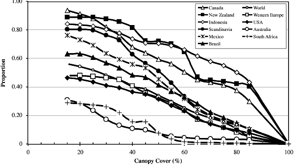
Globally, about 50 percent of wooded land has a canopy cover of less than 20
percent. This figure varies nationally, however, from 10 to about 70 percent.
The amount varies greatly from region to region and country to country (Figure
2-1).
|
|
Figure 2-1: Proportion of wooded land captured
by a percent canopy cover threshold (based on DeFries et al.,
1995).
|
Minimum forest stand dimensions are usually included within forestry definitions
to keep the task of monitoring forested areas feasible. For the purposes of
forestry operations, the limit is often set as low as 0.5 ha (sometimes 0.01
ha), with minimum width of only 10 m. Although such resolution may be required
at the scale of forestry operations, it creates practical difficulties in monitoring
extensive areas for changes (such as those associated with ARD activities).
The cost of monitoring rises sharply with increasing resolution. Thus, in practice,
monitoring and reporting agencies will be constrained by the cost of measurement
programs and by available resources.
If the upper limit of resolution is set too high, however, significant areas
of treed land may be excluded from monitoring or reporting as forest. Similarly,
areas of non-treed land might be reported as forest. Landscape units that consist
of a mixture of forest and non-forest patches may be assigned a cover type that
represents an average value for the area. If the spatial unit is very large,
only very large scale activities will cause the average value to move below
or above a definitional threshold of forest. Thus, smaller scale activities
would be neither detected nor reported.
Ideally, the resolution should be compatible with the scale of human activities
(e.g., clearing, planting, infrastructure). For example, consider an assessment
over an area of 1 km2 of dense forest using a forest definition incorporating
a minimum CPC of 30 percent. Numerous human-induced openings on the scale of
a few hectares could take place within this region without resulting in a decrease
of the average CPC over the assessment area below the 30-percent definitional
threshold; hence, these openings would not be recorded as deforestation. Similarly,
forestation activities in a sparsely treed region may not be detected or recorded
as either reforestation or afforestation.
The maximum spatial unit chosen will involve a tradeoff between practicality
(cost) and the ability to identify areas where actual changes have taken place.
The larger the spatial unit employed, the lower the proportion of ARD activities
detected and recorded. Very large spatial units (coarse resolution) may result
in the detection and recording of lower ARD activity rates. We note, however,
that the detected change in cover resulting from activities may be captured
under Article 3.4 (e.g., associated with aggradation or degradation, respectively)-a
tradeoff that the Parties may wish to keep in mind. Chapter
3 analyzes in one of its definitional scenarios (see Table
3-1) an approach that captures forest degradation/aggradation activities
within modified definitions of deforestation/reforestation.
The use of productivity, or potential timber-volume production, in the definition
of a forest is relatively new in most countries. Such an approach could avoid
the need for explicit rules relating to maximum height and canopy cover, which
to a large extent are surrogates for timber volume and carbon content. From
the perspective of the atmosphere, however, Net Biome Productivity (NBP) (not
simply timber productivity) is a relevant measure (see Chapter
1). From the Kyoto perspective (which focuses on change caused by direct
human-induced land-use change and forestry activities), the cascading changes
in carbon in all of the affected components (living biomass, dead organic matter,
and organic material transported off-site) would need to be included in the
productivity estimate if it is to reflect an accurate appraisal of carbon gains
and losses. We return to this point in Sections 2.2.5
and 2.3 and in Chapters 3 and 4.
|