3.6.3.2 Uptake of anthropogenic CO2 by the ocean
Ocean uptake is constrained to some degree by observations of anthropogenic
tracers. Three transient tracers are commonly used. First, anthropogenic CO2
itself gives a direct benchmark for model estimates of the quantity and distribution
of anthropogenic CO2 that has penetrated the ocean since the pre-industrial
era. Anthropogenic CO2 can be inventoried by an indirect method whereby
carbon concentration is compared to what would be expected from water exposed
to pre-industrial air (Gruber et al., 1996). The 14CO2
released in the early 1960s by atmospheric nuclear testing (commonly called
bomb 14C) provides a second tracer; the content of bomb 14C
in the ocean is used to constrain global air-sea CO2 exchange (Wanninkhof
et al., 1992), and ocean model results can be compared with its penetration
depth as a benchmark for vertical transport (Broecker et al., 1995). Bomb 14C
is computed by subtracting the observed 14C concentration from an
estimate of its pre-industrial value (Broecker et al., 1995). Finally, CFCs
also constrain the downward transport of tracers in ocean models. No natural
background needs to be subtracted from CFCs. None of these three tracers provide
a perfect indicator of anthropogenic CO2 uptake: CO2 equilibrates
with the atmosphere ten times faster than 14C and ten times slower
than CFCs; anthropogenic CO2 and 14C are indirectly estimated.
As part of the Ocean Carbon-Cycle Model Intercomparison Project (OCMIP), a comparison
of carbon models with respect to all three anthropogenic tracers is in progress
(Orr and Dutay, 1999; Orr et al., 2001).
Although regional estimates show discrepancies, modelled estimates of anthropogenic
tracers agree reasonably well with observations when integrated globally. The
mean value of the penetration depth of bomb 14C for all observational
sites during the late 1970s is 390 ± 39 m (Broecker et al., 1995). For
the same years and stations, modelled estimates range between 283 and 376 m
(Orr et al., 2001). Modelled and observed CFC concentrations have been compared
locally but not yet globally (England 1995; Robitaille and Weaver, 1995; Orr
and Dutay, 1999). Modelled anthropogenic CO2 inventory since 1800
is comparable to the estimate of 40 ± 9 PgC for the Atlantic Ocean (Gruber,
1998) and 20 ± 3 PgC for the Indian Ocean (Sabine et al., 1999;
Orr et al., 2001). Latitude-depth profiles of anthropogenic CO2 in
the Atlantic, extracted from data and from models, are shown in Figure
3.9. Modelled CO2 uptake for the global ocean between 1800 and
1990 ranges between 100 and 133 PgC (Figure 3.8),
comparable to the preliminary data-based estimate of 107 ± 27 PgC
for the global ocean, which includes the Pacific value of 45 ± 15
PgC (Feely et al., 1999a). Although in reasonable agreement with basin and global
estimates of anthropogenic CO2, modelled inventories exhibit large
differences at the regional scale: models tend to underestimate the inventory
of anthropogenic CO2 between 50°S and 50°N in the Atlantic
and Indian Oceans, and to overestimate it at high latitudes (Sabine et al.,
1999; Orr et al., 2001). In the Southern Ocean the uptake of anthropogenic CO2
varies by a factor of two among models (Orr et al., 2001). The difficulty for
models in reproducing the spatial structure of anthropogenic tracers may be
indicative of problems in ocean physics mentioned earlier, and may be responsible
for the increasing range of model estimates when future CO2 uptake
is projected by the same models (Figure 3.10c).
The most recent model estimates of the ocean-atmosphere flux obtained with
process-based models are -1.5 to -2.2 for 1980 to 1989 (Table
3.4), in agreement with earlier model estimates for the same period (Enting
et al., 1994; Orr et al., 2001). These estimates are fully consistent with the
budget based on atmospheric observations alone (Table
3.1), with estimates based on pCO2 and  13C
observations (Table 3.4), and with the SAR estimate
of -2.0 ± 0.8 PgC/yr. Figure 3.8 shows modelled
ocean CO2 uptake for 1900 to 2000. (These results do not include
natural variability and therefore appear smoother than in reality.) The oceanic
regions absorbing the largest quantities of anthropogenic CO2 according
to models are those where older waters come in contact with the atmosphere,
such as high latitudes and upwelling regions of the equator. In contrast, modelled
sub-tropical regions rapidly saturate at atmospheric CO2 level and
do not absorb large quantities of anthropogenic CO2 (Sarmiento et
al., 1992; Orr et al., 2001). 13C
observations (Table 3.4), and with the SAR estimate
of -2.0 ± 0.8 PgC/yr. Figure 3.8 shows modelled
ocean CO2 uptake for 1900 to 2000. (These results do not include
natural variability and therefore appear smoother than in reality.) The oceanic
regions absorbing the largest quantities of anthropogenic CO2 according
to models are those where older waters come in contact with the atmosphere,
such as high latitudes and upwelling regions of the equator. In contrast, modelled
sub-tropical regions rapidly saturate at atmospheric CO2 level and
do not absorb large quantities of anthropogenic CO2 (Sarmiento et
al., 1992; Orr et al., 2001).
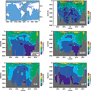
Figure 3.9: Anthropogenic CO2 in the Atlantic Ocean
(mmol/kg): comparison of data and models. The top left panel shows
the sampling transect; the top right panel shows estimates of anthropogenic
CO2 content along this transect using observations from
several cruises between 1981 and 1989 (Gruber, 1998). Anthropogenic
CO2 is not measured directly but is separated from the
large background of oceanic carbon by an indirect method based on
observations (Gruber et al., 1996). The remaining panels show simulations
of anthropogenic CO2 content made with four ocean carbon
models forced by the same atmospheric CO2 concentration
history (Orr et al., 2000). |
|
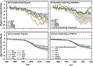
Figure 3.10: Projections of anthropogenic CO2 uptake
by process-based models. Six dynamic global vegetation models were
run with IS92a CO2 concentrations as given in the SAR:
(a) CO2 only, and (b) with these CO2 concentrations
plus simulated climate changes obtained from the Hadley Centre climate
model with CO2 and sulphate aerosol forcing from IS92a
(Cramer et al., 2000). Panel (b) also shows the envelope of the results
from panel (a) (in grey). (c) Ten process-based ocean carbon models
were run with the same CO2 concentrations, assuming a constant
climate (Orr and Dutay, 1999; Orr et al., 2000). A further six models
were used to estimate the climate change impact on ocean CO2
uptake as a proportional change from the CO2-only case.
The resulting changes were imposed on the mean trajectory of the simulations
shown in panel (c), shown by the black line in panel (d), yielding
the remaining trajectories in panel (d). The range of model results
in panel (d) thus represents only the climate change impact on CO2
uptake; the range does not include the range of representations of
ocean physical transport, which is depicted in panel (c). |
|
|