|
2.2 How Much is the World Warming?
2.2.1 Background
The SAR concluded that, on a global average, land-surface air and sea surface
temperature rose by between 0.3°C and 0.6°C between the late 19th century
and 1994. In this section, the recent warming is re-examined, using updated
data. We include recent analyses of the diurnal asymmetry of the warming and
its geographical structure. Conventional temperature observations are supplemented
by indirect evidence and by satellite-based data. For the first time, we make
objective estimates of uncertainties in the surface temperature data, though
these are preliminary. We also assess recent work in compiling hemispheric and
global temperature records from palaeoclimatic data, especially for the most
recent millennium.
2.2.2 Temperature in the Instrumental Record for Land and
Oceans
|
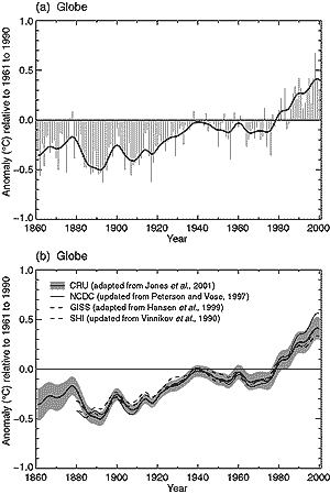
Figure 2.1: (a) Annual anomalies of global average
land-surface air temperature (°C), 1861 to 2000, relative to 1961 to
1990 values. Bars and solid curve are from CRU (Jones et al., 2001).
Values are the simple average of the anomalies for the two hemispheres.
The smoothed curve was created using a 21-point binomial filter giving
near decadal averages. (b) As (a) but smoothed curves only from NCDC
(updated from Peterson and Vose, 1997) thin solid curve; GISS
(adapted from Hansen et al., 1999) thick dashed curve; SHI (updated
from Vinnikov et al., 1990) thin dashed curve to 1999 only; Peterson
and Vose (1997) thin solid curve. Thick solid curve as
in (a). Two standard error uncertainties are centred on the CRU curve
and are estimated using an optimum averaging method (Folland et al.,
2001) and include uncertainties due to urbanisation but not due to uncertainties
in thermometer exposures. The NCDC curve is the weighted average of
the two hemispheres according to the area sampled, which accounts for
most of the differences from the CRU curve.
|
Note that all data sets are adjusted to have zero anomaly when averaged over
the period 1961 to 1990.
2.2.2.1 Land-surface air temperature
The SAR reviewed the three databases of land-surface air temperature due to
Jones (1994), Hansen and Lebedeff (1988) and Vinnikov et al. (1990). The first
and second databases have been updated by Jones et al. (2001) and Hansen et
al. (1999), respectively, and a further analysis has become available (Peterson
and Vose, 1997; Peterson et al., 1998a, 1999). The last paper also separates
rural temperature stations in the Global Historical Climatology Network (GHCN)
(Peterson and Vose, 1997) from the full set of stations which, in common with
the other three analyses, have been screened for urbanisation effects. While
there is little difference in the long-term (1880 to 1998) rural (0.70°C/century)
and full set of station temperature trends (actually less at 0.65°C/century),
more recent data (1951 to 1989), as cited in Peterson et al. (1999), do suggest
a slight divergence in the rural (0.80°C/century) and full set of station
trends (0.92°C/century). However, neither pair of differences is statistically
significant. In addition, while not reported in Peterson et al., the 1951 to
1989 trend for urban stations alone was 0.10°C/decade. We conclude that
estimates of long-term (1880 to 1998) global land-surface air temperature variations
and trends are relatively little affected by whether the station distribution
typically used by the four global analyses is used, or whether a special effort
is made to concentrate on rural stations using elaborate criteria to identify
them. Part of the reason for this lack of sensitivity is that the average trends
in available worldwide urban stations for 1951 to 1989 are not greatly more
than those for all land stations (0.09°C/decade). The differences in trend
between rural and all stations are also virtually unaffected by elimination
of areas of largest temperature change, like Siberia, because such areas are
well represented in both sets of stations.
These results confirm the conclusions of Jones et al. (1990) and Easterling
et al. (1997) that urban effects on 20th century globally and hemispherically
averaged land air temperature time-series do not exceed about 0.05°C over
the period 1900 to 1990 (assumed here to represent one standard error in the
assessed non-urban trends). However, greater urbanisation influences in future
cannot be discounted. Note that changes in borehole temperatures (Section
2.3.2), the recession of the glaciers (Section 2.2.5.4),
and changes in marine temperature (Section 2.2.2.2),
which are not subject to urbanisation, agree well with the instrumental estimates
of surface warming over the last century. Reviews of the homogeneity and construction
of current surface air temperature databases appear in Peterson et al. (1998b)
and Jones et al. (1999a). The latter shows that global temperature anomalies
can be converted into absolute temperature values with only a small extra uncertainty.
Figure 2.1a shows the Jones et al. (2001) CRU (Climatic
Research Unit) annual averages, together with an approximately decadally smoothed
curve, to highlight decadal and longer changes. This is compared with smoothed
curves from the other three analyses in Figure 2.1b.
We do not show standard errors for the CRU land data using the Jones et al.
(1997b) method as tests suggest that these may not be reliable for land data
on its own. Instead we use an optimum averaging method (Folland et al., 2001)
where the calculated uncertainties are centred on the simple CRU average. We
have added an estimate of the additional, independent, uncertainty (twice the
standard error) due to urbanisation increasing from zero in 1900 to 0.12°C
in 2000. (The Jones et al. (1990) estimates can be interpreted as one standard
error equal to 10% of the global warming to that time of about 0.05°C, see also
Box 2.1 on urbanisation.) Note that the warming
substantially exceeds the calculated uncertainties. (We have not included the
possible refinement of assuming urbanisation uncertainties to apply to the cold
side of the trend line only, which would reduce the total uncertainty range
in Figure 2.1.)
|
Box 2.1: Urban Heat Island and the Observed Increases
in Land Air Temperature.
There are two primary reasons why urban heat islands have been suspected
as being partially responsible for the observed increases in land air
temperatures over the last few decades. The first is related to the observed
decrease in the diurnal temperature range and the second is related to
a lower rate of warming observed over the past twenty years in the lower
troposphere compared with the surface.
Since the 1950s both daily maximum and minimum temperatures are available
over more than 50% of the global land area. These data indicate that on
average the mean minimum temperature has increased at nearly twice the
rate of the maximum temperature, reducing the daily temperature range
by about 0.4°C over these areas. This has raised questions related
to whether the growth of urban heat islands may be responsible for a substantial
portion of the observed mean temperature increase, because it is well-known
that compared to non-urban areas urban heat islands raise night-time temperatures
more than daytime temperatures. Nonetheless, the relatively strong correlation
between observed decreases in the daily temperature range with increases
of both precipitation (leading to more moist surface conditions) and total
cloud amount support the notion that the reduction in diurnal temperature
range is in response to these physical changes.
Since 1979 satellite observations and weather balloons (which generally
agree well) show substantially less warming of the global lower troposphere
(around 2 km) than surface temperatures (0.03 and 0.04°C/decade, respectively,
compared to 0.16°C/decade at the surface). However, over the Northern
Hemisphere land areas where urban heat islands are most apparent, both
the trends of lower-tropospheric temperature and surface air temperature
show no significant differences. In fact, the lower-tropospheric temperatures
warm at a slightly greater rate over North America (about 0.28°C/decade
using satellite data) than do the surface temperatures (0.27°C/decade),
although again the difference is not statistically significant. In the
global average, the trend differences arise largely from the tropical
and sub-tropical oceans. In many such regions, the near-surface marine
air temperatures tend to be cool and dense compared with conditions aloft,
allowing for the lapse rate with height, disconnecting near-surface (up
to about 1 km) conditions from higher layers in the atmosphere. Thus the
surface marine layer and the troposphere above can have differing variations
and trends.
Clearly, the urban heat island effect is a real climate change in urban
areas, but is not representative of larger areas. Extensive tests have
shown that the urban heat island effects are no more than about 0.05°C
up to 1990 in the global temperature records used in this chapter to depict
climate change. Thus we have assumed an uncertainty of zero in global
land-surface air temperature in 1900 due to urbanisation, linearly increasing
to 0.06°C (two standard deviations 0.12°C) in 2000.
|
Continues on next page
|